Geolocate

Sundargarh topographic map

Click on the map to display elevation.

Sundargarh

Sundargarh is located at 22°07′N 84°02′E / 22.12°N 84.03°E / 22.12; 84.03. It has an average elevation of 243 metres (801 feet). The Ib river flows along in the north.

Wikipedia (CC-BY-SA 3.0)

About this map

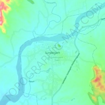
Name: Sundargarh topographic map, elevation, terrain.

Location: Sundargarh, Sundargarh Town, Sundargarh, Odisha, 770001, India (22.08007 83.99721 22.16007 84.07721)

Average elevation: 243 m

Minimum elevation: 214 m

Maximum elevation: 400 m

Gear up for your next adventure:

🌄Outdoor Binoculars - Compact binoculars for landscape observation
📱Rugged Phone Cases - Heavy-duty protection for smartphones used as secondary GPS tools
🛌Insulated Sleeping Mats - Crucial thermal protection when sleeping on cold, uneven ground
🧣Fleece Neck Warmers - Extra insulation for winter topographic surveys
Insulated Travel Mugs - Keep drinks hot while surveying the landscape from a summit

As an Amazon Associate, this site earns from qualifying purchases at no extra cost to you.