
Makhuduthamaga Local Municipality topographic map
Interactive map
Click on the map to display elevation.
About this map
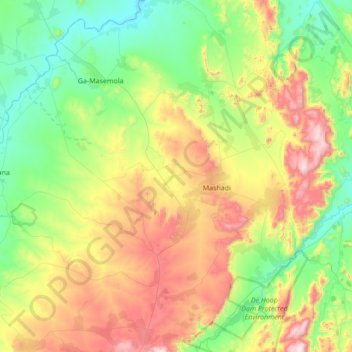
Name: Makhuduthamaga Local Municipality topographic map, elevation, terrain.
Average elevation: 1,140 m
Minimum elevation: 750 m
Maximum elevation: 1,980 m
Other topographic maps
Click on a map to view its topography, its elevation and its terrain.
Ohrigstad
Südafrika > Limpopo > Sekhukhune > Greater Tubatse Local Municipality
Ohrigstad, Greater Tubatse Local Municipality, Sekhukhune, Limpopo, Südafrika
Average elevation: 1,156 m