
Vilanova de Sau topographic map
Interactive map
Click on the map to display elevation.
About this map
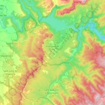
Name: Vilanova de Sau topographic map, elevation, terrain.
Location: Vilanova de Sau, Osona, Barcelone, Catalogne, 08519, Espagne (41.88751 2.36493 41.99730 2.48214)
Average elevation: 619 m
Minimum elevation: 321 m
Maximum elevation: 1,032 m
Other topographic maps
Click on a map to view its topography, its elevation and its terrain.
Sant Pere de Torelló
Sant Pere de Torelló, Osona, Barcelone, Catalogne, 08572, Espagne
Average elevation: 758 m