Geolocate

Moss topographic map

Click on the map to display elevation.

About this map

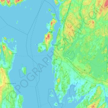
Name: Moss topographic map, elevation, terrain.

Location: Moss, Østfold, Norway (59.29388 10.53668 59.53458 10.82077)

Average elevation: 23 m

Minimum elevation: -2 m

Maximum elevation: 174 m

Other topographic maps

Click on a map to view its topography, its elevation and its terrain.

Askim

Norway > Østfold

Average elevation: 130 m

Heller

Norway > Østfold

Average elevation: 166 m

Ullerøy leirskole

Norway > Østfold > Ullerøy

Average elevation: 14 m

Moss

Norway > Østfold

Average elevation: 42 m

Engelsviken

Norway > Østfold > Fredrikstad

Average elevation: 12 m

Moss

Norway > Østfold

Average elevation: 42 m

Knapstad

Norway > Østfold

Average elevation: 128 m

Leon

Norway > Østfold

Average elevation: 134 m

Knivsøya

Norway > Østfold > Isebakke

Average elevation: 34 m

Kinnekulle

Norway > Østfold

Average elevation: 148 m

Gear up for your next adventure:

📍Handheld GPS Navigators - Reliable satellite navigation for hiking and off-road exploration
🎒Hiking Daypacks (20L) - Compact backpacks for day trips and technical mountain ascents
🛌Insulated Sleeping Mats - Crucial thermal protection when sleeping on cold, uneven ground
📷Camera Straps - Secure straps for carrying cameras while walking
🧭Orienteering Compasses - Accurate compasses for map-based navigation

As an Amazon Associate, this site earns from qualifying purchases at no extra cost to you.