
Bletchingdon topographic map
Click on the map to display elevation.
About this map
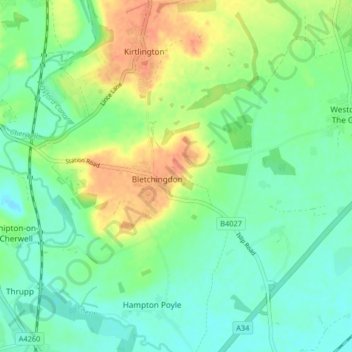
Name: Bletchingdon topographic map, elevation, terrain.
Average elevation: 76 m
Minimum elevation: 57 m
Maximum elevation: 111 m
Oxfordshire trails, hiking, mountain biking, running and outdoor activities
Other topographic maps
Click on a map to view its topography, its elevation and its terrain.
Roman Meadow Banbury Country Park
United Kingdom > England > Oxfordshire > Cherwell District > Little Bourton
Average elevation: 103 m
Williamscot
United Kingdom > England > Oxfordshire > Cherwell District > Cropredy > Williamscot
Average elevation: 118 m
Stoke Lyne
United Kingdom > England > Oxfordshire > Cherwell District > Stoke Lyne
Average elevation: 116 m
Shipton-on-Cherwell
United Kingdom > England > Oxfordshire > Cherwell District
Average elevation: 78 m
Hampton Gay
United Kingdom > England > Oxfordshire > Cherwell District > Shipton-on-Cherwell
Average elevation: 75 m
Little Chesterton
United Kingdom > England > Oxfordshire > Cherwell District > Wendlebury
Average elevation: 72 m
Nethercote
United Kingdom > England > Oxfordshire > Cherwell District > Banbury
Average elevation: 111 m
Down End
United Kingdom > England > Oxfordshire > Cherwell District > Hook Norton
Average elevation: 173 m
Nethercote
United Kingdom > England > Oxfordshire > Cherwell District > Banbury
Average elevation: 111 m