
Make a donation
Gear up for your next adventure:
As an Amazon Associate, this site earns from qualifying purchases at no extra cost to you.
Detroit Lake topographic map
Click on the map to display elevation.
Make a donation
Gear up for your next adventure:
As an Amazon Associate, this site earns from qualifying purchases at no extra cost to you.
Detroit Lake
The water level fluctuates with snow pack, precipitation, and the water consumption of Salem, and surrounding areas. At low pool, it has a surface elevation of 1,450 feet (440 m); at the full pool season—typically May 1 to September 1—it can raise up 119 feet (36 m) to a water elevation of 1,569 feet (478 m).
Make a donation
Gear up for your next adventure:
As an Amazon Associate, this site earns from qualifying purchases at no extra cost to you.
About this map
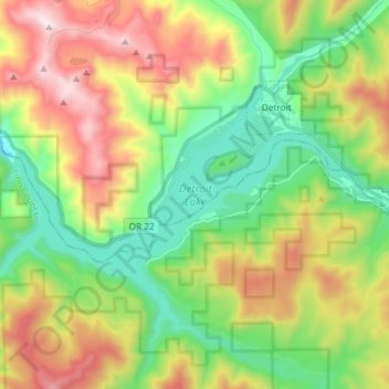
Name: Detroit Lake topographic map, elevation, terrain.
Average elevation: 799 m
Minimum elevation: 371 m
Maximum elevation: 1,487 m
Make a donation
Gear up for your next adventure:
As an Amazon Associate, this site earns from qualifying purchases at no extra cost to you.