
Make a donation
Gear up for your next adventure:
As an Amazon Associate, this site earns from qualifying purchases at no extra cost to you.
Cedar topographic map
Click on the map to display elevation.
Make a donation
Gear up for your next adventure:
As an Amazon Associate, this site earns from qualifying purchases at no extra cost to you.
About this map
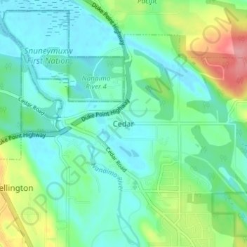
Name: Cedar topographic map, elevation, terrain.
Average elevation: 27 m
Minimum elevation: -1 m
Maximum elevation: 103 m
Make a donation
Gear up for your next adventure:
As an Amazon Associate, this site earns from qualifying purchases at no extra cost to you.
Other topographic maps
Click on a map to view its topography, its elevation and its terrain.
Quennell Lake
Canada > British Columbia > Regional District of Nanaimo > Area A (Cassidy/Cedar)
Average elevation: 40 m
Hemer Provincial Park
Canada > British Columbia > Regional District of Nanaimo > Area A (Cassidy/Cedar)
Average elevation: 36 m
Whiting Way Community Park
Canada > British Columbia > Regional District of Nanaimo > Area A (Cassidy/Cedar)
Average elevation: 47 m