
Modena topographic map
Interactive map
Click on the map to display elevation.
About this map
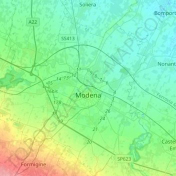
Name: Modena topographic map, elevation, terrain.
Location: Modena, Emilia-Romagna, Italy (44.56295 10.78208 44.74244 11.01227)
Average elevation: 40 m
Minimum elevation: 21 m
Maximum elevation: 104 m
Other topographic maps
Click on a map to view its topography, its elevation and its terrain.
Zocca
Italy > Emilia-Romagna > Modena
Zocca, Unione di comuni Terre di Castelli, Modena, Emilia-Romagna, 41059, Italy
Average elevation: 499 m
Bell'Italia
Italy > Emilia-Romagna > Modena > Maranello
Bell'Italia, Maranello, Unione dei comuni del Distretto Ceramico, Modena, Emilia-Romagna, 41053, Italy
Average elevation: 117 m
Maranello
Italy > Emilia-Romagna > Modena
Maranello, Unione dei comuni del Distretto Ceramico, Modena, Emilia-Romagna, 41053, Italy
Average elevation: 220 m
Fiorano Modenese
Italy > Emilia-Romagna > Modena
Fiorano Modenese, Unione dei comuni del Distretto Ceramico, Modena, Emilia-Romagna, 41042, Italy
Average elevation: 168 m
San Cesario sul Panaro
Italy > Emilia-Romagna > Modena
San Cesario sul Panaro, Unione dei comuni del Sorbara, Modena, Emilia-Romagna, 41018, Italy
Average elevation: 46 m
Soliera
Italy > Emilia-Romagna > Modena
Soliera, Unione delle Terre d'Argine, Modena, Emilia-Romagna, 41019, Italy
Average elevation: 26 m
Montecreto
Italy > Emilia-Romagna > Modena
Montecreto, Unione dei comuni del Frignano, Modena, Emilia-Romagna, 41025, Italy
Average elevation: 998 m
Frassinoro
Italy > Emilia-Romagna > Modena
Frassinoro, Unione dei comuni del Distretto Ceramico, Modena, Emilia-Romagna, 41047, Italy
Average elevation: 1,048 m
Fiumalbo
Italy > Emilia-Romagna > Modena
Fiumalbo, Unione dei comuni del Frignano, Modena, Emilia-Romagna, 41022, Italy
Average elevation: 1,348 m
Sassuolo
Italy > Emilia-Romagna > Modena
Sassuolo, Unione dei comuni del Distretto Ceramico, Modena, Emilia-Romagna, 41049, Italy
Average elevation: 163 m
La Sega
Italy > Emilia-Romagna > Modena > Pievepelago > La Sega
La Sega, Pievepelago, Unione dei comuni del Frignano, Modena, Emilia-Romagna, 41047, Italy
Average elevation: 1,266 m
Sestola
Italy > Emilia-Romagna > Modena
Sestola, Unione dei comuni del Frignano, Modena, Emilia-Romagna, 41029, Italy
Average elevation: 846 m
Lama Mocogno
Italy > Emilia-Romagna > Modena
Lama Mocogno, Unione dei comuni del Frignano, Modena, Emilia-Romagna, Italy
Average elevation: 780 m
Montese
Italy > Emilia-Romagna > Modena
Montese, Modena, Emilia-Romagna, 41055, Italy
Average elevation: 654 m