
Make a donation
Gear up for your next adventure:
As an Amazon Associate, this site earns from qualifying purchases at no extra cost to you.
Yorkley topographic map
Click on the map to display elevation.
Make a donation
Gear up for your next adventure:
As an Amazon Associate, this site earns from qualifying purchases at no extra cost to you.
About this map
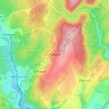
Name: Yorkley topographic map, elevation, terrain.
Average elevation: 113 m
Minimum elevation: 32 m
Maximum elevation: 206 m
Gloucestershire trails, hiking, mountain biking, running and outdoor activities
Make a donation
Gear up for your next adventure:
As an Amazon Associate, this site earns from qualifying purchases at no extra cost to you.
Other topographic maps
Click on a map to view its topography, its elevation and its terrain.
Redmarley D'Abitot
United Kingdom > England > Gloucestershire > Forest of Dean
Average elevation: 46 m
Newent Woods
United Kingdom > England > Gloucestershire > Forest of Dean > May Hill
Average elevation: 157 m
Make a donation
Gear up for your next adventure:
As an Amazon Associate, this site earns from qualifying purchases at no extra cost to you.
Coleford
United Kingdom > England > Gloucestershire > Forest of Dean > Coleford
Average elevation: 193 m
Cinderford
United Kingdom > England > Gloucestershire > Forest of Dean > Littledean
Average elevation: 173 m
Make a donation
Gear up for your next adventure:
As an Amazon Associate, this site earns from qualifying purchases at no extra cost to you.
Make a donation
Gear up for your next adventure:
As an Amazon Associate, this site earns from qualifying purchases at no extra cost to you.
Speech House Lake
United Kingdom > England > Gloucestershire > Forest of Dean
Average elevation: 148 m
Make a donation
Gear up for your next adventure:
As an Amazon Associate, this site earns from qualifying purchases at no extra cost to you.
Newland
United Kingdom > England > Gloucestershire > Forest of Dean > Newland
Average elevation: 151 m
Make a donation
Gear up for your next adventure:
As an Amazon Associate, this site earns from qualifying purchases at no extra cost to you.
Westbury-on-Severn
United Kingdom > England > Gloucestershire > Forest of Dean
Average elevation: 25 m
Aylburton
United Kingdom > England > Gloucestershire > Forest of Dean > Aylburton
Average elevation: 37 m
Make a donation
Gear up for your next adventure:
As an Amazon Associate, this site earns from qualifying purchases at no extra cost to you.
Land Grove
United Kingdom > England > Gloucestershire > Forest of Dean > Mitcheldean
Average elevation: 157 m
Lydney Harbour
United Kingdom > England > Gloucestershire > Forest of Dean > Lydney > Naas
Average elevation: 7 m
Cinderford
United Kingdom > England > Gloucestershire > Forest of Dean > Littledean
Average elevation: 173 m
Make a donation
Gear up for your next adventure:
As an Amazon Associate, this site earns from qualifying purchases at no extra cost to you.
Coleford
United Kingdom > England > Gloucestershire > Forest of Dean > Coleford
Average elevation: 193 m