
Make a donation
Gear up for your next adventure:
As an Amazon Associate, this site earns from qualifying purchases at no extra cost to you.
Ultental topographic map
Click on the map to display elevation.
Make a donation
Gear up for your next adventure:
As an Amazon Associate, this site earns from qualifying purchases at no extra cost to you.
About this map
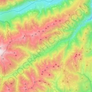
Name: Ultental topographic map, elevation, terrain.
Average elevation: 1,629 m
Minimum elevation: 485 m
Maximum elevation: 3,187 m
Make a donation
Gear up for your next adventure:
As an Amazon Associate, this site earns from qualifying purchases at no extra cost to you.
Other topographic maps
Click on a map to view its topography, its elevation and its terrain.
St. Nikolaus
Italien > Trentino-Südtirol > Bozen > Ulten
St. Nikolaus (italienisch San Nicolò) ist eine Fraktion der Gemeinde Ulten in Südtirol (Italien). Das Dorf liegt auf 1256 m Höhe im waldreichen Ultental, das von hohen Bergen umgeben ist.
Average elevation: 1,649 m
Hasenöhrl
Italien > Trentino-Südtirol > Bozen > Ulten
Das Hasenöhrl, auch Hasenohr genannt (italienischer Name: l’Orecchia di Lepre), ist mit 3257 Metern Höhe ein Gipfel des Zufrittkamms in den Ortler-Alpen, einem Gebirge der südlichen Ostalpen. Es ist der östlichste Berg und Endpunkt des Marteller Hauptkamms, eines von der Fürkelescharte im Westen über…
Average elevation: 2,813 m