Geolocate

Jangla topographic map

Click on the map to display elevation.

About this map

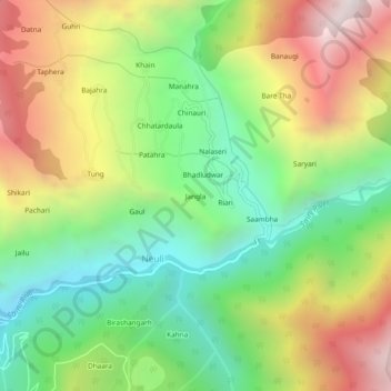
Name: Jangla topographic map, elevation, terrain.

Location: Jangla, Neuli, Sainj, Kullu, Himachal Pradesh, India (31.75913 77.36669 31.79913 77.40669)

Average elevation: 2,140 m

Minimum elevation: 1,515 m

Maximum elevation: 3,002 m

Gear up for your next adventure:

🎒Hiking Daypacks (20L) - Compact backpacks for day trips and technical mountain ascents
🥾Trekking Poles - Poles to improve stability on uneven terrain
📸Action Camera Chest Mounts - Record your ascent following topographic paths hands-free
🧭GPS Trackers - Tracking devices for safety and navigation
🧴Sport Sunscreen Sticks - High-protection sunblock that won't run into your eyes on the trail

As an Amazon Associate, this site earns from qualifying purchases at no extra cost to you.