
Thank you for supporting this site ❤️
Make a donation
Make a donation
Gear up for your next adventure:
As an Amazon Associate, this site earns from qualifying purchases at no extra cost to you.
Jangla topographic map
Click on the map to display elevation.
Thank you for supporting this site ❤️
Make a donation
Make a donation
Gear up for your next adventure:
As an Amazon Associate, this site earns from qualifying purchases at no extra cost to you.
About this map
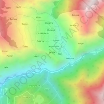
Name: Jangla topographic map, elevation, terrain.
Location: Jangla, Neuli, Sainj, Kullu, Himachal Pradesh, India (31.75913 77.36669 31.79913 77.40669)
Average elevation: 2,140 m
Minimum elevation: 1,515 m
Maximum elevation: 3,002 m
Thank you for supporting this site ❤️
Make a donation
Make a donation
Gear up for your next adventure:
As an Amazon Associate, this site earns from qualifying purchases at no extra cost to you.