
Make a donation
Gear up for your next adventure:
As an Amazon Associate, this site earns from qualifying purchases at no extra cost to you.
Rhodes topographic map
Click on the map to display elevation.
Make a donation
Gear up for your next adventure:
As an Amazon Associate, this site earns from qualifying purchases at no extra cost to you.
About this map
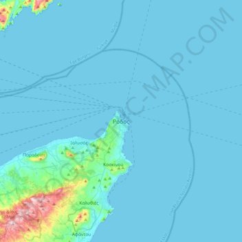
Name: Rhodes topographic map, elevation, terrain.
Average elevation: 28 m
Minimum elevation: 0 m
Maximum elevation: 473 m
Make a donation
Gear up for your next adventure:
As an Amazon Associate, this site earns from qualifying purchases at no extra cost to you.
Other topographic maps
Click on a map to view its topography, its elevation and its terrain.
Make a donation
Gear up for your next adventure:
As an Amazon Associate, this site earns from qualifying purchases at no extra cost to you.
Make a donation
Gear up for your next adventure:
As an Amazon Associate, this site earns from qualifying purchases at no extra cost to you.
Megisti
Greece > Aegean > Rhodes Regional Unit > Municipality of Meyisti
West of the town, beyond the summit of the island known as Vigla (270 m), stands Palaiokastro (old castle), the island's ancient acropolis. This fortified elevation has classical origins (see below, history section): its plan is rectangular and measures 60 by 80 metres (200 ft × 260 ft). In its interior stand…
Average elevation: 40 m