
Make a donation
Gear up for your next adventure:
As an Amazon Associate, this site earns from qualifying purchases at no extra cost to you.
Chiuchiu topographic map
Click on the map to display elevation.
Make a donation
Gear up for your next adventure:
As an Amazon Associate, this site earns from qualifying purchases at no extra cost to you.
Chiuchiu
San Francisco de Chiu Chiu, or simply Chiu Chiu, is a village located about 30 km (19 mi) northeast of the city of Calama, in El Loa Province of Chile's northern Antofagasta Region. It lies at an elevation of 2,525 m (8,284 ft) above sea level, close to the confluence of the Loa and Salado rivers.
Make a donation
Gear up for your next adventure:
As an Amazon Associate, this site earns from qualifying purchases at no extra cost to you.
About this map
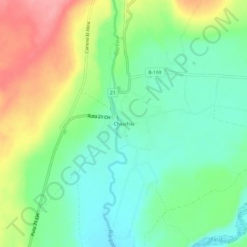
Name: Chiuchiu topographic map, elevation, terrain.
Average elevation: 2,543 m
Minimum elevation: 2,506 m
Maximum elevation: 2,605 m
Make a donation
Gear up for your next adventure:
As an Amazon Associate, this site earns from qualifying purchases at no extra cost to you.