
Kola ward topographic map
Interactive map
Click on the map to display elevation.
About this map
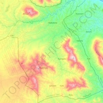
Name: Kola ward topographic map, elevation, terrain.
Location: Kola ward, Machakos Town, Machakos County, Eastern, Kenya (-1.71528 37.23249 -1.52475 37.41291)
Average elevation: 1,577 m
Minimum elevation: 1,235 m
Maximum elevation: 2,066 m
Other topographic maps
Click on a map to view its topography, its elevation and its terrain.