Geolocate

Na Mom topographic map

Interactive map

Click on the map to display elevation.

About this map

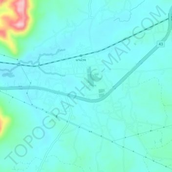
Name: Na Mom topographic map, elevation, terrain.

Location: Na Mom, Ban Rai, Songkhla Province, 90310, Thailand (6.93846 100.53643 6.97846 100.57643)

Average elevation: 43 m

Minimum elevation: 15 m

Maximum elevation: 210 m

Other topographic maps

Click on a map to view its topography, its elevation and its terrain.

Upper Level. Highest accessible level. You won't see Amy other visitors. Good place to take a swim.

Thailand > Songkhla Province

Upper Level. Highest accessible level. You won't see Amy other visitors. Good place to take a swim., Songkhla Province, Thailand

Average elevation: 397 m

Tha Phraya

Thailand > Songkhla Province

Tha Phraya, Songkhla Province, Thailand

Average elevation: 93 m

Hat Yai

Thailand > Songkhla Province

Hat Yai, Kho Hong, Songkhla Province, Thailand

Average elevation: 47 m

Ban Phru

Thailand > Songkhla Province

Ban Phru, Ban Rai, Songkhla Province, 90230, Thailand

Average elevation: 31 m