
Make a donation
Gear up for your next adventure:
As an Amazon Associate, this site earns from qualifying purchases at no extra cost to you.
Clovis topographic map
Click on the map to display elevation.
Make a donation
Gear up for your next adventure:
As an Amazon Associate, this site earns from qualifying purchases at no extra cost to you.
Clovis
Clovis is located in southeastern Curry County at 34°24′45″N 103°12′17″W / 34.41250°N 103.20472°W / 34.41250; -103.20472 (34.412509, −103.204611), 9 miles (14 km) west of the Texas border. The city's geographic center is at an elevation of 4,281 feet (1,305 m) above sea level.
Make a donation
Gear up for your next adventure:
As an Amazon Associate, this site earns from qualifying purchases at no extra cost to you.
About this map
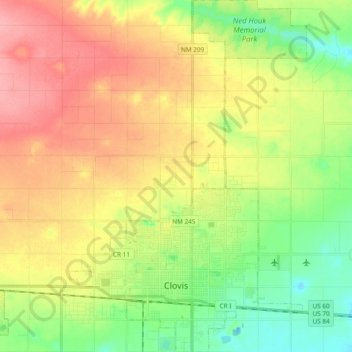
Name: Clovis topographic map, elevation, terrain.
Location: Clovis, Curry County, New Mexico, 88101, United States (34.37570 -103.26236 34.53217 -103.13462)
Average elevation: 1,317 m
Minimum elevation: 1,275 m
Maximum elevation: 1,363 m
Make a donation
Gear up for your next adventure:
As an Amazon Associate, this site earns from qualifying purchases at no extra cost to you.