
Sahale Glacier topographic map
Interactive map
Click on the map to display elevation.
About this map
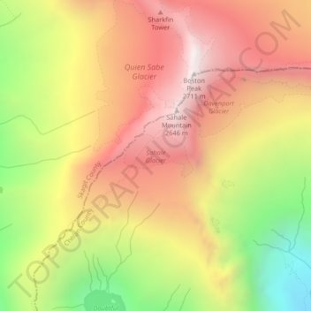
Name: Sahale Glacier topographic map, elevation, terrain.
Location: Sahale Glacier, Chelan County, Washington, United States (48.48560 -121.04529 48.48930 -121.03626)
Average elevation: 2,062 m
Minimum elevation: 1,278 m
Maximum elevation: 2,677 m
Other topographic maps
Click on a map to view its topography, its elevation and its terrain.
Entiat
United States > Washington > Chelan County
Entiat, Chelan County, Washington, United States
Average elevation: 376 m
Lake Wenatchee
United States > Washington > Chelan County
Lake Wenatchee, Chelan County, Washington, United States
Average elevation: 874 m
Dark Peak
United States > Washington > Chelan County
Dark Peak, Chelan County, Washington, United States
Average elevation: 2,058 m
Plain
United States > Washington > Chelan County
Plain, Chelan County, Washington, United States
Average elevation: 673 m
Dragontail Peak
United States > Washington > Chelan County
Dragontail Peak, Chelan County, Washington, United States
Average elevation: 2,235 m
Copper Peak
United States > Washington > Chelan County
Copper Peak, Chelan County, Washington, United States
Average elevation: 2,032 m
Icicle Creek
United States > Washington > Chelan County
Icicle Creek, Chelan County, Washington, United States
Average elevation: 974 m
Labyrinth Mountain
United States > Washington > Chelan County
Labyrinth Mountain, Chelan County, Washington, United States
Average elevation: 1,514 m
Bear Lake
United States > Washington > Chelan County
Bear Lake, Chelan County, Washington, United States
Average elevation: 1,855 m
Wenatchee
United States > Washington > Chelan County
Wenatchee, Chelan County, Washington, 98801, United States
Average elevation: 302 m