
Make a donation
Gear up for your next adventure:
As an Amazon Associate, this site earns from qualifying purchases at no extra cost to you.
Lake Wenatchee topographic map
Click on the map to display elevation.
Make a donation
Gear up for your next adventure:
As an Amazon Associate, this site earns from qualifying purchases at no extra cost to you.
About this map
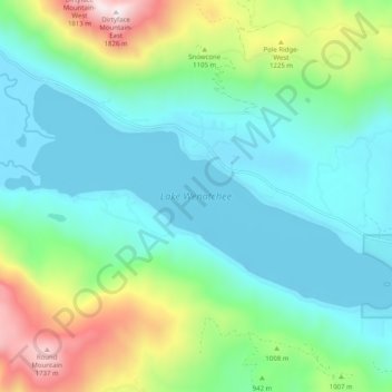
Name: Lake Wenatchee topographic map, elevation, terrain.
Location: Lake Wenatchee, Chelan County, Washington, United States (47.80472 -120.82786 47.84338 -120.72756)
Average elevation: 874 m
Minimum elevation: 564 m
Maximum elevation: 1,819 m
Make a donation
Gear up for your next adventure:
As an Amazon Associate, this site earns from qualifying purchases at no extra cost to you.
Other topographic maps
Click on a map to view its topography, its elevation and its terrain.
Make a donation
Gear up for your next adventure:
As an Amazon Associate, this site earns from qualifying purchases at no extra cost to you.
Make a donation
Gear up for your next adventure:
As an Amazon Associate, this site earns from qualifying purchases at no extra cost to you.
Mount Stuart
United States > Washington > Chelan County
Mount Stuart is more notable for its local relief than for its absolute elevation. For example, the south face rises 5,000 feet (1,500 m) in just 2 horizontal miles (3.2 km). The northeast and northwest sides of the mountain exhibit similar steep relief. Due to its location away from higher peaks, Mount Stuart…
Average elevation: 2,109 m
Make a donation
Gear up for your next adventure:
As an Amazon Associate, this site earns from qualifying purchases at no extra cost to you.
Dragontail Peak
United States > Washington > Chelan County
The Alpine Lakes Wilderness features some of the most rugged topography in the Cascade Range with craggy peaks and ridges, deep glacial valleys, and granite walls spotted with over 700 mountain lakes. Geological events occurring many years ago created the diverse topography and drastic elevation changes over…
Average elevation: 2,235 m
Make a donation
Gear up for your next adventure:
As an Amazon Associate, this site earns from qualifying purchases at no extra cost to you.