
Stendal topographic map
Interactive map
Click on the map to display elevation.
About this map
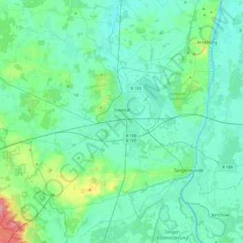
Name: Stendal topographic map, elevation, terrain.
Location: Stendal, Sachsen-Anhalt, 39576, Deutschland (52.48478 11.56867 52.70079 11.97921)
Average elevation: 41 m
Minimum elevation: 24 m
Maximum elevation: 133 m
Aland | Altmärkische Höhe | Altmärkische Wische | Arneburg | Bismark (Altmark) | Eichstedt (Altmark) | Goldbeck | Hassel | Havelberg | Hohenberg-Krusemark | Iden | Kamern | Klietz | Osterburg (Altmark) | Rochau | Sandau (Elbe) | Schollene | Schönhausen (Elbe) | Seehausen (Altmark) | Stendal | Tangerhütte | Tangermünde | Werben (Elbe) | Wust-Fischbeck | Zehrental
Other topographic maps
Click on a map to view its topography, its elevation and its terrain.
Garlipp
Deutschland > Sachsen-Anhalt > Stendal > Bismark (Altmark)
Garlipp, Bismark (Altmark), Stendal, Sachsen-Anhalt, Deutschland
Average elevation: 53 m