
Emilia-Romagna topographic map
Interactive map
Click on the map to display elevation.
About this map
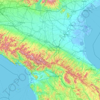
Name: Emilia-Romagna topographic map, elevation, terrain.
Location: Emilia-Romagna, Italy (43.73081 9.19791 45.13950 12.75590)
Average elevation: 222 m
Minimum elevation: -7 m
Maximum elevation: 2,062 m
Other topographic maps
Click on a map to view its topography, its elevation and its terrain.
Rome
Italy > Lazio > Roma Capitale
Although the city centre is about 24 km (15 mi) inland from the Tyrrhenian Sea, the city territory extends to the shore, where the south-western district of Ostia is located. The altitude of the central part of Rome ranges from 13 m (43 ft) above sea level (at the base of the Pantheon) to 139 m (456 ft) above…
Average elevation: 78 m
Val di Fiemme
Italy > Trentino – Alto Adige/Südtirol > Provincia di Trento > Panchià
Average elevation: 1,640 m
Salotta
Italy > Trentino – Alto Adige/Südtirol > South Tyrol > San Ćiascian - St. Kassian - San Cassiano
Average elevation: 1,779 m
Pila
There are more than 24 pistes (>70 km total length), including 4 blue runs, 29 red runs and 4 black runs, with a pipe zone and a slopestyle zone. There is one cable car, 3 gondolas, 8 chairlifts and 5 conveyors. The resort itself is at 1,814 metres altitude, while the highest skiing can be done at 2,700m.
Average elevation: 1,817 m
Champoluc
Italy > Aosta Valley > Ayas
It is one of the 3 main villages in the commune of Ayas, together with Antagnod (where the town hall is located) and Saint-Jacques. It lies at an altitude of 1568 meters in a broad flat part of the upper Ayas valley. Above Champoluc, to the East, is the Plan du Crest (1975 meters), one of the largest ski areas…
Average elevation: 1,968 m
Raas - Rasa
Italy > Trentino – Alto Adige/Südtirol > South Tyrol > Natz-Schabs - Naz-Sciaves
Average elevation: 763 m
Seiser Alm-Gruppe - Gruppo Mont de Sëuc - Gruppo dell'Alpe di Siusi
Italy > Trentino – Alto Adige/Südtirol > South Tyrol > Kastelruth - Castelrotto
Seiser Alm (Italian: Alpe di Siusi, Ladin: Mont Sëuc) is a Dolomite plateau and the largest high-elevation Alpine meadow (German: Alm) in Europe. Located in Italy's South Tyrol province in the Dolomites mountain range, it is a major tourist attraction, notably for skiing and hiking.
Average elevation: 1,466 m
Vignole
Italy > Trentino – Alto Adige/Südtirol > Provincia di Trento > Arco > Bolognano
Average elevation: 388 m
Klobenstein - Collalbo
Italy > Trentino – Alto Adige/Südtirol > South Tyrol > Ritten - Renon
Average elevation: 1,135 m
Castendallo
Italy > Lombardy > Varese > Montegrino Valtravaglia > Bosco Valtravaglia
Average elevation: 491 m
Gisse
Italy > Trentino – Alto Adige/Südtirol > South Tyrol > Ahrntal - Valle Aurina
Average elevation: 1,368 m
Gnates
Italy > Trentino – Alto Adige/Südtirol > South Tyrol > La Val - Wengen - La Valle
Average elevation: 1,504 m