
Make a donation
Gear up for your next adventure:
As an Amazon Associate, this site earns from qualifying purchases at no extra cost to you.
Browns Valley topographic map
Click on the map to display elevation.
Make a donation
Gear up for your next adventure:
As an Amazon Associate, this site earns from qualifying purchases at no extra cost to you.
About this map
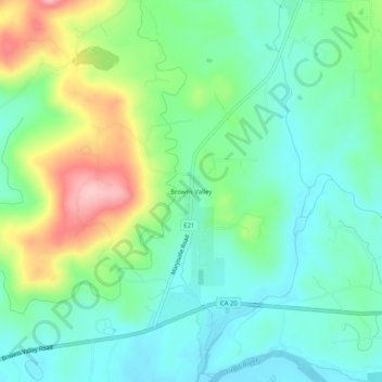
Name: Browns Valley topographic map, elevation, terrain.
Average elevation: 96 m
Minimum elevation: 44 m
Maximum elevation: 213 m
Make a donation
Gear up for your next adventure:
As an Amazon Associate, this site earns from qualifying purchases at no extra cost to you.
Other topographic maps
Click on a map to view its topography, its elevation and its terrain.
Beale AFB
United States > California > Yuba County
On 15 October 1964, the Department of Defense announced that Beale would be the home of the new, supersonic reconnaissance aircraft, the SR-71 Blackbird. The provisional 4200th Strategic Reconnaissance Wing (4200 SRW) activated on 1 January 1965 in preparation for the realignment, and the new wing received its…
Average elevation: 69 m
Make a donation
Gear up for your next adventure:
As an Amazon Associate, this site earns from qualifying purchases at no extra cost to you.
Make a donation
Gear up for your next adventure:
As an Amazon Associate, this site earns from qualifying purchases at no extra cost to you.