
Îlet des Orangers topographic map
Interactive map
Click on the map to display elevation.
About this map
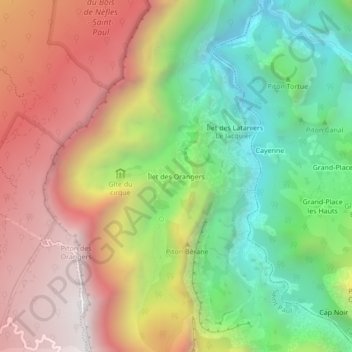
Name: Îlet des Orangers topographic map, elevation, terrain.
Location: Îlet des Orangers, Saint-Paul, La Reunión, Francia (-21.06245 55.37308 -21.02245 55.41308)
Average elevation: 1,127 m
Minimum elevation: 326 m
Maximum elevation: 2,020 m
Other topographic maps
Click on a map to view its topography, its elevation and its terrain.
Marla
Francia > La Reunión > Saint-Paul
Marla, Saint-Paul, La Reunión, 97404, Francia
Average elevation: 1,798 m