Geolocate

Lake Crescent topographic map

Interactive map

Click on the map to display elevation.

About this map

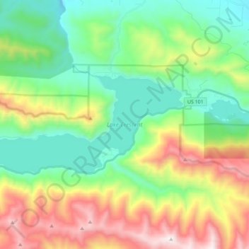
Name: Lake Crescent topographic map, elevation, terrain.

Location: Lake Crescent, Clallam County, Washington, United States (48.04896 -123.91599 48.09473 -123.74224)

Average elevation: 564 m

Minimum elevation: 71 m

Maximum elevation: 1,543 m

Other topographic maps

Click on a map to view its topography, its elevation and its terrain.

Sequim

United States > Washington > Clallam County

Sequim, Clallam County, Washington, United States

Average elevation: 88 m

Port Angeles

United States > Washington > Clallam County

Port Angeles, Clallam County, Washington, 98362, United States

Average elevation: 27 m

Solmar Lake Dam

United States > Washington > Clallam County

Solmar Lake Dam, Clallam County, Washington, United States

Average elevation: 80 m

Clallam Bay

United States > Washington > Clallam County

Clallam Bay, Clallam County, Washington, United States

Average elevation: 39 m

Sunrise View Point

United States > Washington > Clallam County

Sunrise View Point, Hurricane Ridge to Switchback Trail, Clallam County, Washington, United States

Average elevation: 1,397 m

Lake Crescent

United States > Washington > Clallam County

Lake Crescent, Clallam County, Washington, United States

Average elevation: 564 m