
Embalse de Tominé topographic map
Interactive map
Click on the map to display elevation.
About this map
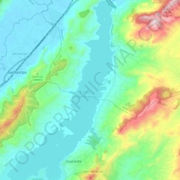
Name: Embalse de Tominé topographic map, elevation, terrain.
Average elevation: 2,745 m
Minimum elevation: 2,551 m
Maximum elevation: 3,317 m
Other topographic maps
Click on a map to view its topography, its elevation and its terrain.
Laguna de Guatavita
Laguna de Guatavita, vía a Laguna de Guatavita, San Jose, Sesquilé, Colombia
Average elevation: 2,995 m