
Lloreda topographic map
Interactive map
Click on the map to display elevation.
About this map
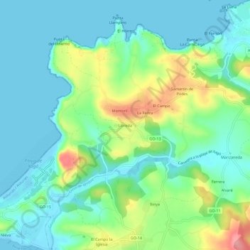
Name: Lloreda topographic map, elevation, terrain.
Location: Lloreda, Gozón, Asturien, Spanien (43.59056 -5.91894 43.63056 -5.87894)
Average elevation: 31 m
Minimum elevation: -2 m
Maximum elevation: 113 m
Other topographic maps
Click on a map to view its topography, its elevation and its terrain.
El Ferrero
El Ferrero, Gozón, Asturien, 33448, Spanien
Average elevation: 44 m