
Minga Porá topographic map
Interactive map
Click on the map to display elevation.
About this map
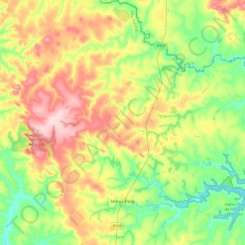
Name: Minga Porá topographic map, elevation, terrain.
Location: Minga Porá, Alto Paraná, Región Oriental, Paraguay (-24.94381 -55.02907 -24.56427 -54.64249)
Average elevation: 311 m
Minimum elevation: 216 m
Maximum elevation: 460 m
Other topographic maps
Click on a map to view its topography, its elevation and its terrain.
Doctor Juan León Mallorquín
Paraguay > Alto Paraná > Doctor Juan León Mallorquín > Doctor Juan León Mallorquín
Average elevation: 250 m