Make a donation
Gear up for your next adventure:
As an Amazon Associate, this site earns from qualifying purchases at no extra cost to you.
Cranleigh topographic map
Click on the map to display elevation.
Make a donation
Gear up for your next adventure:
As an Amazon Associate, this site earns from qualifying purchases at no extra cost to you.
Cranleigh
Elevations range from a maximum of 240 m AOD (mean high water level) at the car park on Reynolds Hill in Winterfold Heath (a woodland in the north) to 41 m on the watercourse and the disused Wey and Arun Canal as they leave both the parish in the northwest extreme at the end of East Whipley Lane. The village centre lies at generally 50–70 m above AOD.
Make a donation
Gear up for your next adventure:
As an Amazon Associate, this site earns from qualifying purchases at no extra cost to you.
About this map
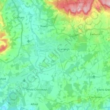
Name: Cranleigh topographic map, elevation, terrain.
Location: Cranleigh, Waverley, Surrey, England, United Kingdom (51.09161 -0.53429 51.17952 -0.44967)
Average elevation: 78 m
Minimum elevation: 24 m
Maximum elevation: 257 m
Surrey trails, hiking, mountain biking, running and outdoor activities
Make a donation
Gear up for your next adventure:
As an Amazon Associate, this site earns from qualifying purchases at no extra cost to you.
Other topographic maps
Click on a map to view its topography, its elevation and its terrain.
Camelsdale
United Kingdom > England > Surrey > Waverley > Haslemere > Shottermill
Average elevation: 166 m
Make a donation
Gear up for your next adventure:
As an Amazon Associate, this site earns from qualifying purchases at no extra cost to you.
Make a donation
Gear up for your next adventure:
As an Amazon Associate, this site earns from qualifying purchases at no extra cost to you.
Make a donation
Gear up for your next adventure:
As an Amazon Associate, this site earns from qualifying purchases at no extra cost to you.
Make a donation
Gear up for your next adventure:
As an Amazon Associate, this site earns from qualifying purchases at no extra cost to you.
Make a donation
Gear up for your next adventure:
As an Amazon Associate, this site earns from qualifying purchases at no extra cost to you.
Hankley Common
United Kingdom > England > Surrey > Waverley > Thursley > Truxford
Average elevation: 70 m
Floodplain (seasonal)
United Kingdom > England > Surrey > Waverley > Farnham > Wrecclesham
Average elevation: 94 m
Make a donation
Gear up for your next adventure:
As an Amazon Associate, this site earns from qualifying purchases at no extra cost to you.
Make a donation
Gear up for your next adventure:
As an Amazon Associate, this site earns from qualifying purchases at no extra cost to you.
Make a donation
Gear up for your next adventure:
As an Amazon Associate, this site earns from qualifying purchases at no extra cost to you.
