
Honeymoon Island topographic map
Interactive map
Click on the map to display elevation.
About this map
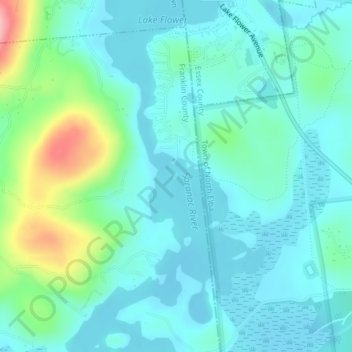
Name: Honeymoon Island topographic map, elevation, terrain.
Average elevation: 489 m
Minimum elevation: 461 m
Maximum elevation: 597 m
Other topographic maps
Click on a map to view its topography, its elevation and its terrain.
Yaphank
United States of America > New York > Yaphank
Yaphank, Suffolk, New York, 11980, United States of America
Average elevation: 24 m
Saratoga County
United States of America > New York
Saratoga County, New York, United States of America
Average elevation: 218 m
Westchester
United States of America > New York
Westchester, New York, United States of America
Average elevation: 95 m
Farmingville
United States of America > New York > Farmingville
Farmingville, Suffolk, New York, 11738, United States of America
Average elevation: 47 m
Essex County
United States of America > New York
Essex County, New York, United States of America
Average elevation: 418 m
Riverhead
United States of America > New York > Riverhead
Riverhead, Suffolk County, New York, United States of America
Average elevation: 13 m
Syracuse
United States of America > New York > Syracuse
Syracuse, Onondaga County, New York, United States of America
Average elevation: 172 m
Barrytown
United States of America > New York > Barrytown
Barrytown, Town of Red Hook, Dutchess, New York, 12507, United States of America
Average elevation: 34 m
Sullivan County
United States of America > New York
Sullivan County, New York, United States of America
Average elevation: 435 m
Chenango County
United States of America > New York
Chenango County, New York, United States of America
Average elevation: 442 m
Saint Lawrence County
United States of America > New York
Saint Lawrence County, New York, United States of America
Average elevation: 239 m
Nassau County
United States of America > New York
Nassau County, New York, United States of America
Average elevation: 18 m