
Le Chenay topographic map
Interactive map
Click on the map to display elevation.
About this map
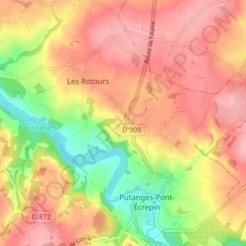
Name: Le Chenay topographic map, elevation, terrain.
Average elevation: 188 m
Minimum elevation: 119 m
Maximum elevation: 233 m
Other topographic maps
Click on a map to view its topography, its elevation and its terrain.
Les Courtils
France > Normandie > Orne > Putanges-le-Lac > Putanges-Pont-Écrepin
Les Courtils, Putanges-Pont-Écrepin, Putanges-le-Lac, Argentan, Orne, Normandie, France métropolitaine, 61210, France
Average elevation: 186 m