
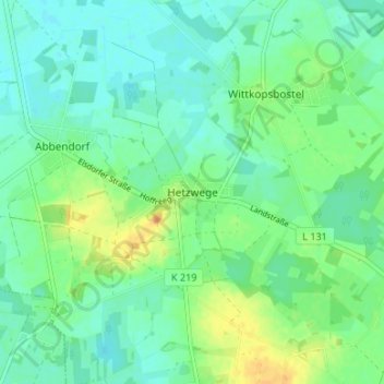
Hetzwege topographic map
Interactive map
Click on the map to display elevation.
About this map
Name: Hetzwege topographic map, elevation, terrain.
Average elevation: 34 m
Minimum elevation: 24 m
Maximum elevation: 56 m
Other topographic maps
Click on a map to view its topography, its elevation and its terrain.
Deepen
Deutschland > Niedersachsen > Landkreis Rotenburg (Wümme) > Scheeßel
Deepen, Scheeßel, Landkreis Rotenburg (Wümme), Niedersachsen, Deutschland
Average elevation: 37 m
Scheeßel
Deutschland > Niedersachsen > Landkreis Rotenburg (Wümme) > Scheeßel
Scheeßel, Landkreis Rotenburg (Wümme), Niedersachsen, 27383, Deutschland
Average elevation: 32 m
Westeresch
Deutschland > Niedersachsen > Landkreis Rotenburg (Wümme) > Scheeßel > Westeresch
Westeresch, Scheeßel, Landkreis Rotenburg (Wümme), Niedersachsen, 27383, Deutschland
Average elevation: 35 m