
Ahsahka topographic map
Interactive map
Click on the map to display elevation.
About this map
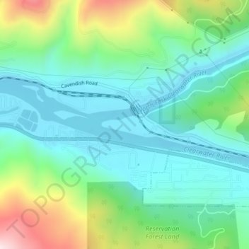
Name: Ahsahka topographic map, elevation, terrain.
Location: Ahsahka, Clearwater County, Idaho, 83520, United States (46.49212 -116.33403 46.51212 -116.31403)
Average elevation: 422 m
Minimum elevation: 290 m
Maximum elevation: 775 m
Other topographic maps
Click on a map to view its topography, its elevation and its terrain.
Weippe
United States > Idaho > Clearwater County
Weippe, Clearwater County, Idaho, 83553, United States
Average elevation: 926 m
Elk River
United States > Idaho > Clearwater County
Elk River, Clearwater County, Idaho, 83827, United States
Average elevation: 907 m
Pierce
United States > Idaho > Clearwater County
Pierce, Clearwater County, Idaho, 83546, United States
Average elevation: 1,004 m
Orofino
United States > Idaho > Clearwater County > Orofino > Orofino
Orofino, Clearwater County, Idaho, 83544, United States
Average elevation: 627 m
Orofino
United States > Idaho > Clearwater County
Orofino, Clearwater County, Idaho, 83544, United States
Average elevation: 633 m