
Susanville topographic map
Interactive map
Click on the map to display elevation.
Susanville
Susanville (formerly known as Rooptown) is a city in and is the county seat of Lassen County, California, United States. Susanville is located on the Susan River in the southern part of the county, at an elevation of 4,186 feet (1,276 m). Its population is 16,728 as of the 2020 census, down from 17,947 from the 2010 census. The Susanville urban area contains 8,995 people and 4,233 households.
About this map
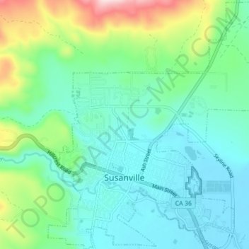
Name: Susanville topographic map, elevation, terrain.
Location: Susanville, Lassen County, California, United States (40.40125 -120.67414 40.45356 -120.60664)
Average elevation: 1,345 m
Minimum elevation: 1,262 m
Maximum elevation: 1,611 m
Other topographic maps
Click on a map to view its topography, its elevation and its terrain.