Geolocate

Utorda topographic map

Click on the map to display elevation.

About this map

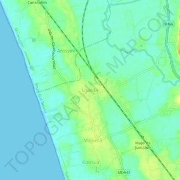
Name: Utorda topographic map, elevation, terrain.

Location: Utorda, Salcete, South Goa District, Goa, 403713, India (15.30431 73.88972 15.34431 73.92972)

Average elevation: 9 m

Minimum elevation: 0 m

Maximum elevation: 29 m

Other topographic maps

Click on a map to view its topography, its elevation and its terrain.

Sal

India > Goa > Salcete > Parlmar Grande

Average elevation: 15 m

Gear up for your next adventure:

🧵Survival Paracord - Multi-purpose cordage for emergency repairs and shelters
🧭Emergency Beacons - Safety beacons for remote outdoor locations
💧Hydration Reservoirs - Convenient water bladders for hands-free drinking on the move
🔋Lithium AA Batteries - Long-lasting power that performs well in cold mountain weather
🌦️Portable Weather Meters - Handheld tools for monitoring weather conditions

As an Amazon Associate, this site earns from qualifying purchases at no extra cost to you.