
Abella de la Conca topographic map
Interactive map
Click on the map to display elevation.
About this map
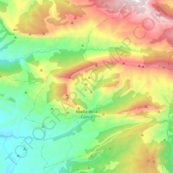
Name: Abella de la Conca topographic map, elevation, terrain.
Location: Abella de la Conca, Pallars Jussà, Lerida, Catalonië, Spanje (42.12735 1.03992 42.23022 1.18632)
Average elevation: 1,156 m
Minimum elevation: 593 m
Maximum elevation: 2,043 m
Other topographic maps
Click on a map to view its topography, its elevation and its terrain.
Tremp
Spanje > Catalonië > Pallars Jussà
Tremp, Pallars Jussà, Catalonië, Spanje
Average elevation: 908 m
Senterada
Spanje > Catalonië > Pallars Jussà
Senterada, Pallars Jussà, Lerida, Catalonië, 25514, Spanje
Average elevation: 1,143 m