
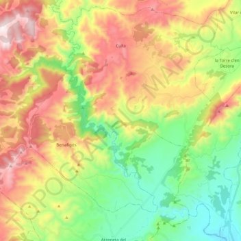
Culla topographic map
Interactive map
Click on the map to display elevation.
About this map
Name: Culla topographic map, elevation, terrain.
Average elevation: 702 m
Minimum elevation: 285 m
Maximum elevation: 1,272 m
Other topographic maps
Click on a map to view its topography, its elevation and its terrain.
la Garrotxa
Spain > Valencian Community > Castelló / Castellón > Cervera del Maestre
Average elevation: 273 m
Vila-real
Spain > Valencian Community > Castelló / Castellón > Vila-real > Vila-real
Average elevation: 42 m
Bassa de Ferrara
Spain > Valencian Community > Castelló / Castellón > la Pobla Tornesa
Average elevation: 477 m
Plaza Antigua Fábrica Fernando Diago
Spain > Valencian Community > Castelló / Castellón > Castelló de la Plana
Average elevation: 35 m