
Dhayet Bendhahoua topographic map
Interactive map
Click on the map to display elevation.
About this map
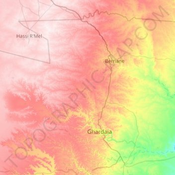
Name: Dhayet Bendhahoua topographic map, elevation, terrain.
Average elevation: 607 m
Minimum elevation: 362 m
Maximum elevation: 804 m
Other topographic maps
Click on a map to view its topography, its elevation and its terrain.
Dhayat sidi belkacem
Algeria > Ghardaia > Dhaïa Ben Dhahoua District > Dhayet Bendhahoua
Dhayat sidi belkacem, Dhayet Bendhahoua, Dhaïa Ben Dhahoua District, Ghardaia, Algeria
Average elevation: 630 m