
Thank you for supporting this site ❤️
Make a donation
Make a donation
Gear up for your next adventure:
As an Amazon Associate, this site earns from qualifying purchases at no extra cost to you.
Amba topographic map
Click on the map to display elevation.
Thank you for supporting this site ❤️
Make a donation
Make a donation
Gear up for your next adventure:
As an Amazon Associate, this site earns from qualifying purchases at no extra cost to you.
About this map
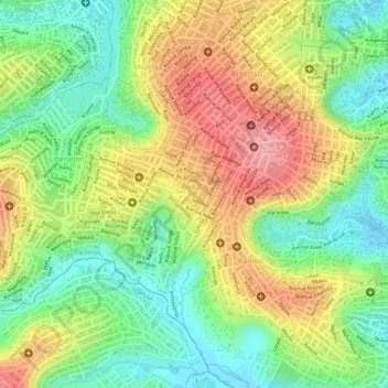
Name: Amba topographic map, elevation, terrain.
Location: Amba, Kisenso, Kinshasa, Democratic Republic of the Congo (-4.42819 15.32839 -4.41436 15.34334)
Average elevation: 353 m
Minimum elevation: 296 m
Maximum elevation: 415 m
Thank you for supporting this site ❤️
Make a donation
Make a donation
Gear up for your next adventure:
As an Amazon Associate, this site earns from qualifying purchases at no extra cost to you.
Other topographic maps
Click on a map to view its topography, its elevation and its terrain.
Parc Naturel de la Nsele (Mangiers)
Democratic Republic of the Congo > Kinshasa
Average elevation: 276 m