
Thank you for supporting this site ❤️
Make a donation
Make a donation
Gear up for your next adventure:
As an Amazon Associate, this site earns from qualifying purchases at no extra cost to you.
Omumasaka topographic map
Click on the map to display elevation.
Thank you for supporting this site ❤️
Make a donation
Make a donation
Gear up for your next adventure:
As an Amazon Associate, this site earns from qualifying purchases at no extra cost to you.
About this map
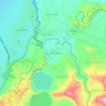
Name: Omumasaka topographic map, elevation, terrain.
Location: Omumasaka, Rubirizi, Western Region, Uganda (-0.23036 30.09019 -0.19036 30.13019)
Average elevation: 1,086 m
Minimum elevation: 979 m
Maximum elevation: 1,332 m
Thank you for supporting this site ❤️
Make a donation
Make a donation
Gear up for your next adventure:
As an Amazon Associate, this site earns from qualifying purchases at no extra cost to you.