
Make a donation
Gear up for your next adventure:
As an Amazon Associate, this site earns from qualifying purchases at no extra cost to you.
Union topographic map
Click on the map to display elevation.
Make a donation
Gear up for your next adventure:
As an Amazon Associate, this site earns from qualifying purchases at no extra cost to you.
Union
According to the United States Census Bureau, the town has a total area of 34.49 square miles (89.33 km2), of which, 32.15 square miles (83.27 km2) of it is land and 2.34 square miles (6.06 km2) is water. Union is drained by the Medomak River, Saint George River, Pettengill Stream, Fuller Brook, Hope Brook, Little Medomak Brook and the Back River. Coggans Hill, elevation 817 feet (249 meters) above sea level, is the highest point in the town.
Make a donation
Gear up for your next adventure:
As an Amazon Associate, this site earns from qualifying purchases at no extra cost to you.
About this map
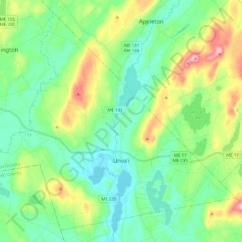
Name: Union topographic map, elevation, terrain.
Location: Union, Knox County, Maine, 04862, United States (44.17291 -69.37375 44.29456 -69.18535)
Average elevation: 89 m
Minimum elevation: 5 m
Maximum elevation: 303 m
Make a donation
Gear up for your next adventure:
As an Amazon Associate, this site earns from qualifying purchases at no extra cost to you.
Other topographic maps
Click on a map to view its topography, its elevation and its terrain.