Geolocate

Sulina topographic map

Click on the map to display elevation.

About this map

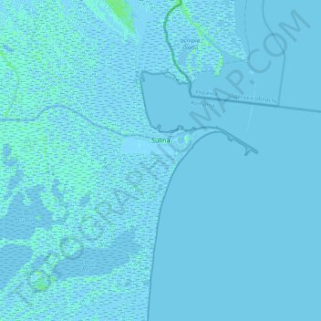
Name: Sulina topographic map, elevation, terrain.

Location: Sulina, Tulcea, 825400, Romania (45.03968 29.39411 45.23842 29.76841)

Average elevation: 0 m

Minimum elevation: -5 m

Maximum elevation: 6 m

Other topographic maps

Click on a map to view its topography, its elevation and its terrain.

Tulcea

Romania > Tulcea

Average elevation: 25 m

La Tene

Romania > Tulcea > Cârjelari

Average elevation: 217 m

Sălcioara

Romania > Tulcea

Average elevation: 16 m

Islazu

Romania > Tulcea > Hamcearca

Average elevation: 184 m

Vasile Alecsandri

Romania > Tulcea

Average elevation: 258 m

Caraorman

Romania > Tulcea

Average elevation: 1 m

Lăstuni

Romania > Tulcea

Average elevation: 36 m

Pătlăgeanca

Romania > Tulcea

Average elevation: 4 m

Pietrosu Mic

Romania > Tulcea > Luncavița

Average elevation: 308 m

Dealul cu Drum

Romania > Tulcea > Greci

Average elevation: 168 m

Tudor Vladimirescu

Romania > Tulcea > Tulcea

Average elevation: 15 m

Zebil

Romania > Tulcea > Zebil

Average elevation: 20 m

Cataloi

Romania > Tulcea

Average elevation: 58 m

Gear up for your next adventure:

👟Waterproof Leg Gaiters - Keep mud and water out of your boots in boggy terrain
🔦LED Camping Lanterns - Illumination for reading maps inside your tent at night
💧Hydration Reservoirs - Convenient water bladders for hands-free drinking on the move
🔦Waterproof LED Headlamps - Hands-free lighting for evening treks and emergency navigation
🥫Expedition Meals - Lightweight, high-calorie nutrition for long-distance hikers

As an Amazon Associate, this site earns from qualifying purchases at no extra cost to you.