
Make a donation
Gear up for your next adventure:
As an Amazon Associate, this site earns from qualifying purchases at no extra cost to you.
Elm Grove topographic map
Click on the map to display elevation.
Make a donation
Gear up for your next adventure:
As an Amazon Associate, this site earns from qualifying purchases at no extra cost to you.
About this map
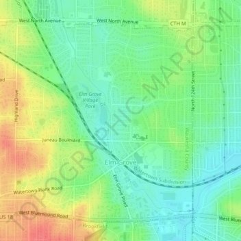
Name: Elm Grove topographic map, elevation, terrain.
Location: Elm Grove, Waukesha County, Wisconsin, 53122, United States (43.03581 -88.10723 43.06041 -88.06682)
Average elevation: 240 m
Minimum elevation: 217 m
Maximum elevation: 275 m
Make a donation
Gear up for your next adventure:
As an Amazon Associate, this site earns from qualifying purchases at no extra cost to you.
Other topographic maps
Click on a map to view its topography, its elevation and its terrain.
Menomonee Falls
United States > Wisconsin > Waukesha County > Menomonee Falls
Average elevation: 260 m
Make a donation
Gear up for your next adventure:
As an Amazon Associate, this site earns from qualifying purchases at no extra cost to you.