Geolocate

Howick topographic map

Click on the map to display elevation.

About this map
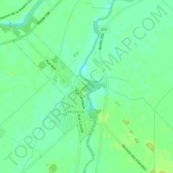
Name: Howick topographic map, elevation, terrain.

Location: Howick, Le Haut-Saint-Laurent, Montérégie, Quebec, Canada (45.18002 -73.86311 45.19759 -73.84385)

Average elevation: 39 m

Minimum elevation: 32 m

Maximum elevation: 45 m

Other topographic maps

Click on a map to view its topography, its elevation and its terrain.
Snye

Canada > Quebec > Le Haut-Saint-Laurent > Snye

Average elevation: 49 m

Cazaville

Canada > Quebec > Le Haut-Saint-Laurent

Average elevation: 58 m

Covey Hill

Canada > Quebec > Le Haut-Saint-Laurent > Havelock

Average elevation: 283 m

Doréa

Canada > Quebec > Le Haut-Saint-Laurent > Franklin

Average elevation: 242 m

Gear up for your next adventure:

🧴Tick Removal Tools - Small, essential health tool for UK woodland and moorland
🧥Breathable Waterproof Jackets - Essential rain protection for the unpredictable British climate
🧭Emergency Beacons - Safety beacons for remote outdoor locations
🥾Women's Waterproof Hiking Boots - High-performance trekking boots designed for all-weather comfort
🧊Insulated Flasks - Keeps drinks hot or cold during hikes

As an Amazon Associate, this site earns from qualifying purchases at no extra cost to you.