
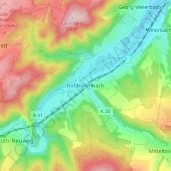
Nahbollenbach topographic map
Interactive map
Click on the map to display elevation.
About this map
Name: Nahbollenbach topographic map, elevation, terrain.
Average elevation: 332 m
Minimum elevation: 214 m
Maximum elevation: 500 m
Other topographic maps
Click on a map to view its topography, its elevation and its terrain.
Mittelbollenbach
Deutschland > Rheinland-Pfalz > Landkreis Birkenfeld > Idar-Oberstein
Mittelbollenbach, Idar-Oberstein, Landkreis Birkenfeld, Rheinland-Pfalz, Deutschland
Average elevation: 399 m
Kirchenbollenbach
Deutschland > Rheinland-Pfalz > Landkreis Birkenfeld > Idar-Oberstein
Kirchenbollenbach, Idar-Oberstein, Landkreis Birkenfeld, Rheinland-Pfalz, Deutschland
Average elevation: 425 m
Weierbach
Deutschland > Rheinland-Pfalz > Landkreis Birkenfeld > Idar-Oberstein > Weierbach
Weierbach, Idar-Oberstein, Landkreis Birkenfeld, Rheinland-Pfalz, Deutschland
Average elevation: 305 m