

Hiko topographic map
Click on the map to display elevation.
Hiko
The Hiko and Crystal Springs provide a large supply of water for the Hiko farms and ranches. The Hiko farming community is located in the north end of the Pahranagat Valley and lies at an elevation of 3,869 feet (1,179 m), with a ZIP code of 89017.
About this map
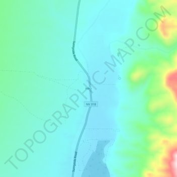
Name: Hiko topographic map, elevation, terrain.
Location: Hiko, Lincoln County, Nevada, United States (37.57606 -115.24424 37.61606 -115.20424)
Average elevation: 1,233 m
Minimum elevation: 1,169 m
Maximum elevation: 1,505 m
Other topographic maps
Click on a map to view its topography, its elevation and its terrain.

Caliente
United States > Nevada > Lincoln County
Caliente /kæliˈɛni/, /kæliˈɛnti/, formerly known as Culverwell and Calientes, is a city in Lincoln County, Nevada, United States. Its elevation is 4,300 feet (1,300 m). The population was 1,130 at the 2010 census, making it the least populated incorporated city in Nevada. The city's name originated from…
Average elevation: 1,439 m
Caliente
United States > Nevada > Lincoln County
Caliente has a high-desert climate typical for a location around 4,000 feet (1,200 m) in elevation. Winters are chilly, but only moderately cold. Summers are characterized by blazing sunshine, long days, cool nights, and high diurnal temperature range. January highs average in the mid 40s, while July averages…
Average elevation: 1,446 m
Caliente
United States > Nevada > Lincoln County
Caliente has a high-desert climate typical for a location around 4,000 feet (1,200 m) in elevation. Winters are chilly, but only moderately cold. Summers are characterized by blazing sunshine, long days, cool nights, and high diurnal temperature range. January highs average in the mid 40s, while July averages…
Average elevation: 1,446 m