Geolocate

Kwidzyn topographic map

Click on the map to display elevation.

About this map

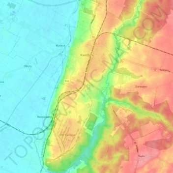
Name: Kwidzyn topographic map, elevation, terrain.

Location: Kwidzyn, Kwidzyn County, Pomeranian Voivodeship, Poland (53.68479 18.90151 53.75614 18.98905)

Average elevation: 45 m

Minimum elevation: 9 m

Maximum elevation: 92 m

Other topographic maps

Click on a map to view its topography, its elevation and its terrain.

Rodowo

Poland > Pomeranian Voivodeship > Kwidzyn County > Rodowo

Average elevation: 99 m

Gear up for your next adventure:

❄️Walking Crampons - Added traction for icy slopes and winter peak bagging
🕶️Polarized Sunglasses - Reduces glare from snow and water when reading terrain
🌄Outdoor Binoculars - Compact binoculars for landscape observation
📷Camera Straps - Secure straps for carrying cameras while walking
📐Altimeters & Barometers - Tools for measuring altitude and air pressure

As an Amazon Associate, this site earns from qualifying purchases at no extra cost to you.