
Make a donation
Gear up for your next adventure:
As an Amazon Associate, this site earns from qualifying purchases at no extra cost to you.
Pigeon Bay topographic map
Click on the map to display elevation.
Make a donation
Gear up for your next adventure:
As an Amazon Associate, this site earns from qualifying purchases at no extra cost to you.
About this map
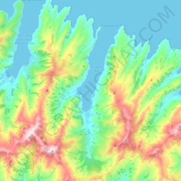
Name: Pigeon Bay topographic map, elevation, terrain.
Average elevation: 243 m
Minimum elevation: 0 m
Maximum elevation: 829 m
Make a donation
Gear up for your next adventure:
As an Amazon Associate, this site earns from qualifying purchases at no extra cost to you.
Other topographic maps
Click on a map to view its topography, its elevation and its terrain.
Takamatua
New Zealand > Canterbury > Christchurch City > Banks Peninsula Community
Average elevation: 101 m
Akaroa
New Zealand > Canterbury > Christchurch City > Banks Peninsula Community
Average elevation: 108 m
Un named plug
New Zealand > Canterbury > Christchurch City > Banks Peninsula Community > Diamond Harbour
Average elevation: 164 m
Barrys Bay
New Zealand > Canterbury > Christchurch City > Banks Peninsula Community
Average elevation: 100 m
Make a donation
Gear up for your next adventure:
As an Amazon Associate, this site earns from qualifying purchases at no extra cost to you.
Haytor
New Zealand > Canterbury > Christchurch City > Banks Peninsula Community
Average elevation: 348 m
Brasenose
New Zealand > Canterbury > Christchurch City > Banks Peninsula Community
Average elevation: 483 m