
Make a donation
Gear up for your next adventure:
As an Amazon Associate, this site earns from qualifying purchases at no extra cost to you.
Moorsel topographic map
Click on the map to display elevation.
Make a donation
Gear up for your next adventure:
As an Amazon Associate, this site earns from qualifying purchases at no extra cost to you.
Moorsel
Ce village, entouré de Vossem, Sterrebeek, Kortenberg, Leefdaal et Tervuren, est situé sur le plateau brabançon ondoyant entre 85 et 90 m d'altitude. Ce hameau résidentiel combine à la fois un caractère rural et périurbain ce qui se caractérise par une alternance de champs, de villas et de vieilles maisons. En son cœur, se trouve une étendue boisée: le bois de Moorsel (Moorselbos). Au nord de Moorsel se trouve le haut bois (Hogenbos).
Make a donation
Gear up for your next adventure:
As an Amazon Associate, this site earns from qualifying purchases at no extra cost to you.
About this map
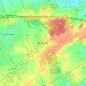
Name: Moorsel topographic map, elevation, terrain.
Average elevation: 75 m
Minimum elevation: 44 m
Maximum elevation: 111 m
Make a donation
Gear up for your next adventure:
As an Amazon Associate, this site earns from qualifying purchases at no extra cost to you.
Other topographic maps
Click on a map to view its topography, its elevation and its terrain.