
Make a donation
Gear up for your next adventure:
As an Amazon Associate, this site earns from qualifying purchases at no extra cost to you.
Tambopata National Reserve topographic map
Click on the map to display elevation.
Make a donation
Gear up for your next adventure:
As an Amazon Associate, this site earns from qualifying purchases at no extra cost to you.
Tambopata National Reserve
The area consists of forested hills and plains, with elevations ranging from 200 to 400 m above sea level.[3] The area presents swamps, oxbow lakes and meandering rivers; the main rivers in the reserve being the Tambopata, Malinowski and Heath rivers.[3]
Make a donation
Gear up for your next adventure:
As an Amazon Associate, this site earns from qualifying purchases at no extra cost to you.
About this map
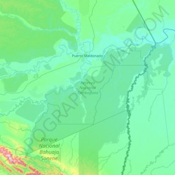
Name: Tambopata National Reserve topographic map, elevation, terrain.
Location: Tambopata National Reserve, Madre de Dios, Peru (-13.17306 -70.09986 -12.50385 -68.73176)
Average elevation: 239 m
Minimum elevation: 152 m
Maximum elevation: 1,245 m
Make a donation
Gear up for your next adventure:
As an Amazon Associate, this site earns from qualifying purchases at no extra cost to you.
Other topographic maps
Click on a map to view its topography, its elevation and its terrain.