Geolocate

Choco topographic map

Click on the map to display elevation.

About this map

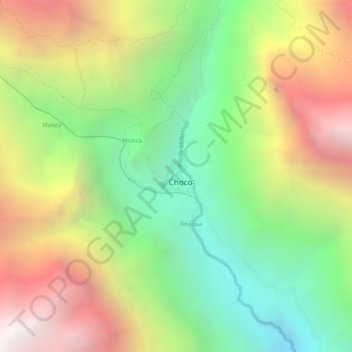
Name: Choco topographic map, elevation, terrain.

Location: Choco, Province of Castilla, Arequipa, Peru (-15.57804 -72.13067 -15.57501 -72.12786)

Average elevation: 2,867 m

Minimum elevation: 2,111 m

Maximum elevation: 3,711 m

Gear up for your next adventure:

🧊Insulated Flasks - Keeps drinks hot or cold during hikes
🌂Windproof Trekking Umbrellas - Surprising but effective rain protection on low-wind trails
🔋Solar Power Banks - Keep your GPS and phone charged during multi-day expeditions
🚲Cycling GPS Computers - Track elevation and topographic routes on two wheels
📢Survival Whistles - Essential safety gear for signaling for help in mountain fog

As an Amazon Associate, this site earns from qualifying purchases at no extra cost to you.